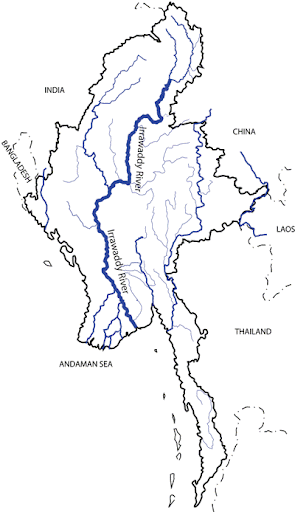
ဧရာ၀တီျမစ္ Irrawaddy River
ကုလသမဂၢ သဘာဝ ပတ္ဝန္းက်င္အစီအစဥ္ (UN Environment Program) ၏ ကမၻာ့
ပတ္ဝန္းက်င္ ထိန္းသိမ္းမႈ ေစာင့္ ၾကည့္ေရး ဌာန (World Conservation
Monitoring Centre) က ဧရာဝတီျမစ္ကို ၎၏ ဇီဝသတၱဝါ စံုလင္ေထြျပားျခင္း ႏွင့္
အနာဂတ္ကာလတြင္ ဖိစီးၿခိမ္းေျခာက္မႈခံရဖြယ္ အေၾကာင္းမ်ားေၾကာင့္
ကမၻာေပၚတြင္ ဦးစားေပးထိန္းသိမ္းရမည့္ ျမစ္ဝွမ္း (၃ဝ) တြင္ စာရင္း
ထည့္သြင္းထားခဲ့ပါသည္။ သိရွိထားေသာ အခ်က္မ်ားအရ ဧရာဝတီျမစ္တြင္
ငါးမ်ဳိးစိတ္ေပါင္း (၇၉) မ်ဳိး ခိုလႈံရာေနထိုင္ၾကသည့္အျပင္၊ ၂ဝဝ၂ ခုႏွစ္
အထိေလ့လာခ်က္မ်ားအရ ဧရာဝတီျမစ္ဝွမ္း၌ လူအမ်ား အသိ အမွတ္ျပဳထားေသာ
ငွက္စားက်က္နယ္ေျမ (၄) ခုလည္း ရွိသည္။ ျမစ္၏ ဇီဝသတၱ
စံုလင္ေထြျပားမႈအေၾကာင္းႏွင့္ ပတ္သက္၍ ေကာင္းစြာေလ့လာထားသည္မ်ားလည္း
မရွိေသးေခ်။ မၾကာေသးမီက ေတာင္က်ေခ်ာင္း ငါးခူမ်ဳိးစိတ္ သစ္မ်ားကို
ထပ္မံေတြ႔ရွိခဲ့ၿပီး၊ ဧရာဝတီျမစ္ဆံုႏွင့္ သိပ္မေဝးလွေသာေနရာမ်ားတြင္ ၂ဝဝ၅
ခုႏွစ္က ေတြ႔ရွိခဲ့ရျခင္း ျဖစ္သည္။ ဧရာဝတီျမစ္သည္ ကမၻာေပၚတြင္ ပဥၥမေျမာက္
ႏံုးတင္ေျမႏွစ္မ်ား အမ်ားဆံုးပို႔ခ်ေပးႏိုင္ေသာျမစ္လည္း ျဖစ္သည္။
ဧရာဝတီျမစ္သည္
ျမန္မာႏိုင္ငံ၏ ဗဟိုခ်က္မေနရာမ်ားကို ျဖတ္သန္း စီးဆင္းသြားသည္။
ျမစ္ဝွမ္းသည္ (၄၁၃, ၆၇၄) စတုရန္းကီလိုမီတာ က်ယ္ဝန္းၿပီး၊ ျမန္မာႏိုင္ငံ
စုစုေပါင္းအက်ယ္အဝန္း၏ (၆၁) ရာခိုင္ႏႈန္းကို လႊမ္းျခံဳထားသည္။
ဧရာဝတီျမစ္သည္ ျမစ္ေၾကာင္းအလွ်ား (၂, ၁၇ဝ) ကီလိုမီတာနီးပါး ရွည္လွ်ားၿပီး၊
တိုင္းျပည္၏ အေရးအႀကီးဆံုး ကူးသန္းေရာင္းဝယ္ေရး ေရေၾကာင္းလမ္းလည္း ျဖစ္သည္။
ဧရာဝတီျမစ္သည္
ကခ်င္ျပည္နယ္ရွိ မလိခႏွင့္ အင္မိုင္ခ (ေမခ) ျမစ္မ်ားေပါင္းဆံုရာမွေန၍
စတင္စီးဆင္းသည္။ ဤျမစ္ဖ်ား ခံရာ ျမစ္ႏွစ္စင္းလံုးသည္ ဟိမဝႏၱာေတာင္တန္း၏
အေရွ႔ေတာင္ပိုင္းေဒသမွ ျမစ္ဖ်ားခံလာျခင္း ျဖစ္သည္။ အင္မိုင္ချမစ္ သည္
ပူတာအိုေျမာက္ဘက္ရွိ လင္ေဂြလာ ေရခဲေတာင္ထြဋ္ (Languela Glacier)
မွာ စတင္ေပၚ ထြန္းသည္။ ျမစ္ဆံုသည္ ကခ်င္ျပည္နယ္ၿမိဳ႔ေတာ္
ျမစ္ႀကီးနားၿမိဳ႔၏ ေျမာက္ဘက္ (၂၈) မိုင္ အကြာတြင္ တည္ရွိသည္။ ဧရာ၀တီအတြင္း
စီး၀င္သည့္ အဓိကေရေ၀ျမစ္ ၃ ခုမွာ ခ်င္းတြင္း၊ ေရႊလီႏွင့္ ျမစ္ငယ္ျမစ္တို႔
ျဖစ္ၾကသည္။ ျမန္မာႏိုင္ငံ အလယ္ဗဟိုကို ျဖတ္သန္းစီးဆင္း လာရင္း
ေတာင္ဖက္ပိုင္းတြင္ ျမန္မာႏိုင္ငံ၏ ဒုတိယအႀကီးဆံုးၿမိဳ႔ေတာ္ မႏၱေလးအနီး၌
ဆံုၾကသည္။ ျမစ္သည္ ျမန္မာႏိုင္ငံ ၏ ဗဟိုခ်က္မေဒသမ်ားႏွင့္ တိုင္းျပည္၏
ဒုတိယအႀကီးဆံုး ၿမိဳ႔ျဖစ္ေသာ မႏၱေလးၿမိဳ႔ကို ျဖတ္သန္း စီးဆင္းသြားသည္။
မႏၱေလးၿမိဳ႔အနီးတြင္ ဧရာ၀တီျမစ္အတြင္း၌ ရွားပါးမ်ဳိးတုန္းေတာ့မည္ ျဖစ္ေသာ ဧရာ၀တီလင္းပိုင္မ်ား မွီတင္းေနထိုင္ေနၾက ပါသည္။ Orcaella brevirostris
ဟု သိပၸံအမည္ေပးထားေသာ လင္းပိုင္မ်ားသည္ ကမၻာေပၚတြင္ ၄-မ်ဳိးသာ
က်န္ရွိေတာ့ သည့္ ေရခ်ဳိလင္းပိုင္ငါးမ်ားအနက္မွ ရွားပါးမ်ဳိးႏြယ္၀င္
ျဖစ္ပါသည္။ သို႔ေသာ္လည္း လြန္ခဲ့သည့္ ရာစုႏွစ္အတြင္း ဧရာ၀တီ ျမစ္အတြင္း
ေနထိုင္ၾကသည့္ ေရခ်ဳိလင္းပိုင္ငါး အေရအတြက္ ၆၀% အထိ ေလ်ာ့က်သြားခဲ့ပါသည္။
ယခုအခ်ိန္တြင္ ရရွိႏိုင္ သမွ်ေသာ အေကာင္းဆံုးခန္႔မွန္းထားသည့္
ဧရာ၀တီလင္းပိုင္ငါး အေရအတြက္မွာ ၅၉ ေကာင္သာ ျဖစ္ပါသည္။
ဤလင္းပိုင္ငါးမ်ားသည္
၂ မီတာမွ ၂. ၇၅ မီတာအထိ အလ်ားရွိၾကၿပီး၊ အျပာနက္ေမွာင္အေရာင္ႏွင့္
မီးခိုးေရာင္အရင့္ အေရာင္ရွိၾကပါသည္။ ဤလင္းပိုင္ငါးမ်ားသည္ လူမ်ားႏွင့္
ရင္းႏွီးစြာ ေပါင္းသင္း၍ ပူးေပါင္းဆက္ဆံမႈ ရွိၾကၿပီး၊ ဤအခ်က္ မွာ လူႏွင့္
တိရိစၦာန္မ်ား ဆက္ဆံေရးအတြက္ ေလ့လာမႈျပဳရန္ အထူးအခြင့္ေကာင္း ျဖစ္ပါသည္။
ငါးမ်ား ေရႊ႔ေျပာင္းသြားလာ မႈ ပံုစံေျပာင္းလာျခင္း၊ ေရ
အရည္အေသြးက်ဆင္းလာျခင္း၊ ျမစ္ေၾကာင္းေရစီးမ်ား ေျပာင္းလဲျခင္းေၾကာင့္
၎ေရသတၱ၀ါ မ်ား အေရအတြက္လည္း က်ဆင္းလာေနပါသည္။ ဧရာ၀တီျမစ္၊ ေမခ၊ မလိချမစ္မ်ားတြင္
ဆည္မ်ား တည္ေဆာက္မည္ဆို ပါက မူလကတည္းက ရွားပါးမ်ဳိးႏြယ္၀င္ျဖစ္ေနေသာ
ဧရာ၀တီလင္းပိုင္ငါးမ်ား ရွားပါးေပ်ာက္ကြယ္ေစရန္ ၿခိမ္းေျခာက္မႈႀကီး
ျဖစ္ေနေစပါေတာ့သည္။
ျမစ္အေၾကတြင္ ဧရာ၀တီျမစ္သည္ ျမစ္လက္တက္ ၉ ခုျဖင့္ အက္ဒမန္ပင္လယ္ထဲသို႔ စီးဆင္းေပါင္း၀င္သြားသည္။
ျမစ္ေအာက္ပိုင္းျဖစ္ေသာ
ဧရာဝတီျမစ္ဝကြၽန္းေပၚေဒသသည္ က်ယ္ဝန္း၍ ေျမဆီေျမႏွစ္ျပည့္ဝေသာ
ေျမျပန္႔လြင္ျပင္တခု ျဖစ္ၿပီး၊ အလ်ား (၂၉ဝ) ကီလိုမီတာႏွင့္ အနံ (၂၄ဝ)
ကီလိုမီတာ ရွိသည္။ ျမစ္ဝကြၽန္းေပၚေဒသ ေအာက္ပိုင္းသည္ လမု ရႊံ႔ၫြံေတာႏွင့္
ဒီေရေရာက္ ျမစ္ဝေဒသျဖစ္ၿပီး၊ ထိခိုက္လြယ္ေသာ ႏူးညံ့သိမ္ေမြ႔ေသာ
ေဂဟစနစ္တခုလည္း ျဖစ္သည္။ ျမစ္ဝကြၽန္းေပၚေဒသသည္ လူဦးေရ (၃)
သန္းေက်ာ္မွီတင္းေနထိုင္ရာျဖစ္ၿပီး၊ ျမန္မာႏိုင္ငံ ဆန္စပါးအထြက္၏ (၆ဝ)
ရာခိုင္ ႏႈန္းနီးပါးကို ဤေဒသကထုတ္လုပ္ ျဖည့္ဆည္းေပးေနသည္။ သို႔ျဖစ္ေစကာမူ
ျမစ္ဝကြၽန္းေပၚေဒသေန ျပည္သူတို႔သည္ စစ္အစိုးရ၏ အခြန္အတုတ္ဖိစီးမႈႏွင့္
ေျမယာပိုင္ဆိုင္ခြင့္မဲ့ေနမႈတို႔ေၾကာင့္ ဆိုးရြားျပင္းထန္ေသာ
ဆင္းရဲမြဲေတမႈဒဏ္ကို ခံစားေနၾကရပါသည္။ ပုဂၢလိကပိုင္
ပုဇြန္ေမြးလုပ္ငန္းမ်ား စည္းကမ္းမဲ့လုပ္ကိုင္ေနၾကမႈႏွင့္
သစ္ေတာျပဳန္းတီးမႈမ်ားေၾကာင့္ သဘာဝပတ္ဝန္းက်င္မ်ား ပ်က္စီး
ဆံုးရႈံးေနၾကရၿပီး၊ ကမၻာ႔ေတာရိုင္းတိရစၦာန္မ်ား ရန္ပံုေငြအဖြဲ႔ (World
Wildlife Fund) က ဧရာဝတီ ေရခ်ဳိ ရႊံ႔ၫြံေတာမ်ားရွိ ေဂဟစနစ္အတြင္း
ေနထိုင္ေနၾကေသာ ေတာရိုင္းတိရစၦာန္မ်ားအဖို႔ အနာဂတ္ရွင္သန္ ႏိုင္ေရး သည္
"အထူးစိုးရိမ္ဖြယ္ အေျခအေနဆိုးရြားေနေၾကာင္း" ေဖာ္ျပခဲ့ပါသည္။
ဧရာ၀တီျမစ္ကို ပိတ္ဆို႔၍ ဆည္တည္ေဆာက္ေနျခင္း (Damming the Irrawaddy) မွ စာသားျဖစ္သည္။
ဧရာ၀တီျမစ္၏ ေရအရင္းအျမစ္ႏွင့္ ပတ္သက္၍ eAtlas ေျမပံုကိုၾကည့္ရန္ ဤေနရာကို ကလစ္ပါ။
The United Nations Environment Programme’s World Conservation
Monitoring Centre lists the Irrawaddy as one of the world’s top thirty
high priority river basins due to both its support of high biodiversity
and high vulnerability to future pressures. The river is home to 79
known fish species and as of 2002 there were four known endemic bird
areas in the basin. The biodiversity of the river is still not well
studied; a new species of hill stream catfish was discovered as
recently as 2005. The Irrawaddy is the fifth most heavily silted river
in the world.
The
Irrawaddy River flows through the heartlands of Burma. The river’s
basin is 413,674 square kilometers, covering a remarkable 61% of
Burma’s total area. At approximately 2,170 kilometers long, it is
Burma’s most important commercial waterway.
The Irrawaddy
originates at the confluence of the Mali Hka and N’Mai Hka rivers in
Kachin State. The headwaters of both rivers originate in the
southeastern Himalayas. The N’Mai rises in the Languela Glacier north
of Putao. The confluence is 28 miles (45 km) north of the Kachin State
capital of Myitkyina. Three major tributaries, the Chindwin,
Shweli, and Myintge, meet the river as it flows south through Burma’s
central heartland, and the country’s second largest city of Mandalay.
Near
Mandalay the river is habitat to the critically endangered Irrawaddy
Dolphin. Orcaella brevirostris is one of only four species of river
dolphins in the world. However, the dolphins’ habitat in the Irrawaddy
has declined nearly 60% in the last century, and the best estimate of
the current population is just 59 individuals.
The dolphins
reach 2-2.75 meters in length, are dark blue to dark gray and have a
unique cooperative fishing relationship with humans which offers
science an amazing opportunity to study the relationship between man
and animal. The loss of prey due to disturbances in fish migration
patterns, the degradation of water quality, and the change in river
hydrology caused by the Irrawaddy/N’Mai/Mali dams upstream may become a serious threat to the already endangered and special Irrawaddy dolphins.
Downstream,
the river empties into the Andaman Sea through a nine-armed delta. The
delta consists of a large and fertile plain that is 290 km long and 240
km wide. The lower part of the delta is a fragile and intricate
ecosystem of mangrove swamps and tidal estuaries. The delta supports a
population of over three million people and provides nearly 60% of
Burma’s total rice production. However, many people in the delta suffer
from extreme poverty caused in part by the heavy levying of taxes by
the regime and a lack of land rights. Private prawn farms and
deforestation have destroyed the environment to such an extent that the
World Wildlife Fund called the future survival of wildlife in the
Irrawaddy freshwater swamp forest ecoregion “bleak.”
Text from Damming the Irrawaddy
To see the Water Resources eAtlas for the Irrawaddy click here
Labels: ေဆာင္းပါး


 ေရးမိေရးရာ ဟိုျခစ္ ဒီေရး »
 Open album »
 Open album »
 Open album »
0 Comments:
Post a Comment
Subscribe to Post Comments [Atom]
<< Home